User testimonials
SEA 3D seismic image analysis software (ffA)
powered by Open Inventor
By Stephen Purves, Technical Director at ffA.
ffA is a world leading provider of software and services to the seismic interpretation segment of the global oil and gas market. ffA’s image processing and analysis software enables geoscientists to enhance, identify and extract geological objects from 3D seismic datasets repeatably and objectively. ffA selected Open Inventor as the core 3D visualization component for its product line. Open Inventor is an object-oriented, cross-platform 3D graphics toolkit for the development of industrial-strength interactive applications. SEA 3D Pro 2008 is the latest version of ffA’s popular seismic image analysis plug-in for GeoProbe®. SEA 3D Pro 2008 maintains the seamless integration with GeoProbe experienced previously, but now provides access to a much wider range of data processing modules in a user friendly environment that supports batch processing of user defined workflows. This expanded range of modules incorporates ffA’s noise cancellation, fault imaging and seismic attribute generation capabilities including CarbApp, a new workflow specifically developed for highlighting geological features within complex carbonate environments. About ffA: Foster Findlay Associates Limited (“ffA”) is a world leader in the development and commercialisation of 3D seismic image processing technology for the oil and gas industry. About Open Inventor: Open Inventor® is an object-oriented 3D software development toolkit (SDK) for the development of professional interactive applications using C++, .NET or Java, on Cloud, desktop, and mobile environments. Its easy-to-use API, extensible architecture, and large set of advanced built-in components provide developers with a high-level platform for integrating, in a simple and consistent way, powerful 3D visualization and analysis capabilities into software applications for the energy sector. Images and text are courtesy of ffA. |
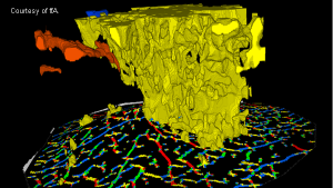
↑ A complex gas chimney geobody has been extracted along with its surrounding fault network.
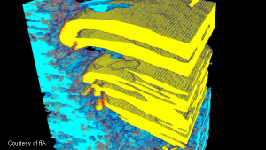
↑ RGB blend of a complex geobody representing gas migration pathways through a dataset. Changes in color clearly indicate the 3D variation in subsurface frequency properties throughout the geobody when opacity rendered. |