用户推荐
Mapping and surface modeling software (Petrosys)
powered by Open Inventor
By Petrosys.
|
In the complicated game of petroleum exploration and production, the stakes are high, and great maps are vital to the decision-making process. Based on Open Inventor, Petrosys’ 3d-viz allows the user to work confidently with a complex collection of surfaces, and to produce maps of extraordinary precision and detail. The Petrosys development team chooses Open Inventor because of it’s unrivalled 3D graphics capabilities, easy integration into its development process and support of Windows and Linux desktop environments. Extend dynamic petrosys presentation optionsBuild up and display compelling 3D models using a collection of Petrosys grids, Landmark, GeoFrame, Petrel and other surfaces, well tracks, projected maps and raster images. Take advantage of horizontal and vertical clipping planes, multiple light sources, a raster hard copy, movie making facilities and full interactive controls from any Windows or Linux desktop. Control surface model qualityDisplay Petrosys computed grids in 3D views, along with the associated well data, to control gridding process quality while improving the viewer’s understanding of the subsurface structure. Directly visualize surfaces from GeoFrame, OpenWorks, ArcSDE, Petrel, Petra, GoCad, ArcSDE, RESCUE models and more. Bring surface and subsurface knowledge to lightDrape raster images on surfaces for potential field or other information not available in grid form to be tied to locations on surfaces in depth, or to clarify the geographic position of subsurface points by overlaying satellite images. Integrate well knowledgePost and annotate well tracks and downhole information from the Petrosys well data file and other popular industry well data sources such as OpenWorks, Petrel, GeoFrame and many more to allow visual correlation of downhole and computed surface data. About Petrosys:Petrosys is a mapping and data visualization application tailored to the needs of the hands-on professional in petroleum exploration and production. About Open Inventor:Open Inventor® is an object-oriented 3D software development toolkit (SDK) for the development of professional interactive applications using C++, .NET or Java, on Cloud, desktop, and mobile environments. Its easy-to-use API, extensible architecture, and large set of advanced built-in components provide developers with a high-level platform for integrating, in a simple and consistent way, powerful 3D visualization and analysis capabilities into software applications for the energy sector. Images and text are courtesy of Petrosys. |
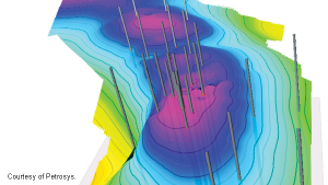
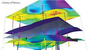
↑ A collection of complex surfaces can be manipulated and viewed from virtually any perspective, allowing you to see clearly both the surface and the subsurface knowledge.
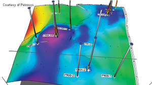
↑ In Petrosys 3D, it’s very easy to review surface intercepts and to validate the proposed relationship of your well, zone and structures in the process.
|