SoGeoLOD Class Reference
[Geographic nodes]
 Level-of-detail management for multi-resolution terrains.
More...
Level-of-detail management for multi-resolution terrains.
More...
#include <Inventor/geo/SoGeoLOD.h>
Public Member Functions | |
| virtual SoType | getTypeId () const |
| SoGeoLOD () | |
| SoGeoLOD (int nChildren) | |
Static Public Member Functions | |
| static SoType | getClassTypeId () |
Public Attributes | |
| SoMFString | geoSystem |
| SoSFString | child1Url |
| SoSFString | child2Url |
| SoSFString | child3Url |
| SoSFString | child4Url |
| SoSFString | rootUrl |
| SoSFFloat | range |
| SoSFVec3d | center |
Detailed Description
Level-of-detail management for multi-resolution terrains.
The SoGeoLOD node allows applications to build massive tiled, multi-resolution terrain models where the viewer progressively loads higher resolution detail as you fly into the terrain.
VRML X3D SPECIFICATION
- This section describes the expected behavior of the node in a conforming X3D / VRML97 browser application. In some cases, the application is responsible for implementing portions of the expected behavior. Open Inventor viewer classes and IVF classes implement some of the application behaviors.
This section may reference portions of the X3D specification that are not present in this help file. The complete X3D spec is available at http://www.web3d.org .
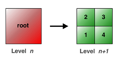
The SoGeoLOD node provides a terrain-specialized form of the LOD node. It is a grouping node that specifies two different levels of detail for an object using a tree structure, where 0 to 4 children can be specified, and also efficiently manages the loading and unloading of these levels of detail. The level of detail is switched depending upon whether the user is closer or further than range meters from the geospatial coordinate center. The center field should be specified as described in 25.2.4 Specifying geospatial coordinates. The geoSystem field is used to define the spatial reference frame and is described in 25.2.3 Specifying a spatial reference frame. When the user is outside the specified range, only the geometry for rootUrl or rootNode are displayed. When the viewer enters the specified range, this geometry is replaced with the contents of the four children files defined by child1Url through child4Url. The four children files are loaded into memory only when the user is within the specified range. Similarly, these are unloaded from memory when the user leaves this range. Figure below illustrates this process. The child URLs shall be arranged in the same order as in the figure; i.e., child1Url represents the bottom-left quadtree child. It is valid to specify less than four child URLs; in which case, the SoGeoLOD should switch to the children nodes when all of the specified URLs have been loaded. This latter feature can support tree structures other than quadtrees, such as binary trees.
The rootUrl and rootNode fields provide two different ways to specify the geometry of the root tile. You may use one or the other. The rootNode field lets you include the geometry for the root tile directly within the X3D file; whereas the rootUrl field lets you specify a URL for a file that contains the geometry. The result of specifying a value for both of these fields is undefined.
FILE FORMAT/DEFAULT
- GeoLOD {
| center | 0 0 0 |
| child1Url | [] |
| child2Url | [] |
| child3Url | [] |
| child4Url | [] |
| geoSystem | ["GD","WE"] |
| range | 10 |
| rootUrl | [] |
ACTION BEHAVIOR
- SoGLRenderAction, SoCallbackAction, SoGetBoundingBoxAction, SoRayPickAction, SoGetPrimitiveCountAction
- GC: Earth-fixed Geocentric with respect to the WGS84 ellipsoid.
- GD: Geodetic spatial reference frame.
An optional second string may be used to specify the ellipsoid using one of the ellipsoid codes that are defined in X3D. If no ellipsoid is specified, then "WE" is assumed (the WGS84 ellipsoid). - UTM: Universal Transverse Mercator
One further required argument must be supplied for UTM in order to specify the zone number (1..60). This is given in the form "Zn", where n is the zone number. An optional argument of "S" may be supplied in order to specify that the coordinates are in the southern hemisphere (otherwise, northern hemisphere will be assumed). - Inventor/geo/SoGeoLOD.h
Constructor & Destructor Documentation
| SoGeoLOD::SoGeoLOD | ( | ) |
Constructor.
| SoGeoLOD::SoGeoLOD | ( | int | nChildren | ) |
Constructor that takes approximate number of children.
Member Function Documentation
| static SoType SoGeoLOD::getClassTypeId | ( | ) | [static] |
Returns the type identifier for this class.
Reimplemented from SoGroup.
| virtual SoType SoGeoLOD::getTypeId | ( | ) | const [virtual] |
Returns the type identifier for this specific instance.
Reimplemented from SoGroup.
Member Data Documentation
Object-space center of the model.
First child url : bottom-left quadtree child.
Second child url : up-left quadtree child.
Third child url : up-right quadtree child.
Fourth child url : bottom-right quadtree child.
Defines the spatial reference frame.
Valid values are:
World-space distance to use as switching criteria.
Url of the file that contains the root tile geometry.
The documentation for this class was generated from the following file: